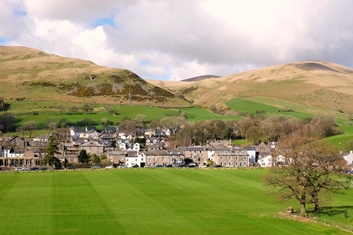
Sedbergh, The Howgills and The Yorkshire Dales

The old market town of Sedbergh is situated in the western end of the Yorkshire Dales National Park. For centuries the town has served the social and commercial needs of Dales farming communities, but now Sedbergh has become something of a visitor hub.
Sedbergh is a real magnet for walkers. The Dales Way meanders along the banks of the Dee, the Rawthey and the Lune, passing within half a mile of the town.
For the more adventurous walker, the top of Winder gives access to the rest of the Howgills to the North and also affords magnificent views of Morecambe Bay, the Lakeland Fells and the Three Peaks. (OK, you actually have to get half way up Brant Fell to get a good view of all three of The Peaks, but it's not far).
It is also one of three 'Book Towns' in the UK, the others being Hay–on–Wye (in Wales) and Wigtown (in Scotland). It's not as big as the other two but it has a number of shops selling mostly second–hand books that are well worth a little rootle.
Sedbergh Visitor Information


- For information about walking routes, maps, guides and walking groups, go to our Walking Page.
- For general visitor information visit the Sedbergh Information and Book Centre web page.
- Visit the Sedbergh Lookaround website, mainly for local news, but also for things to do in the surrounding dales, towns and villages.
- Visit the Dales Way website, for information about a walking route that runs from Ilkley to Bowness–on–Windermere, via Grassington, Dent and Sedbergh.
- Visit the Dales High Way website for details of a 90 mile waymarked route from Saltaire, via Settle, Ingleborough and Sedbergh, to Appleby–in–Westmorland.

